FLOOD OUTLOOK GUIDE
Excessive Rainfall Outlook levels, explained
What Marginal, Slight, Moderate and High risk mean on the Weather Prediction Center's flood outlook, and what to do at each level.
Reading excessive rainfall risk
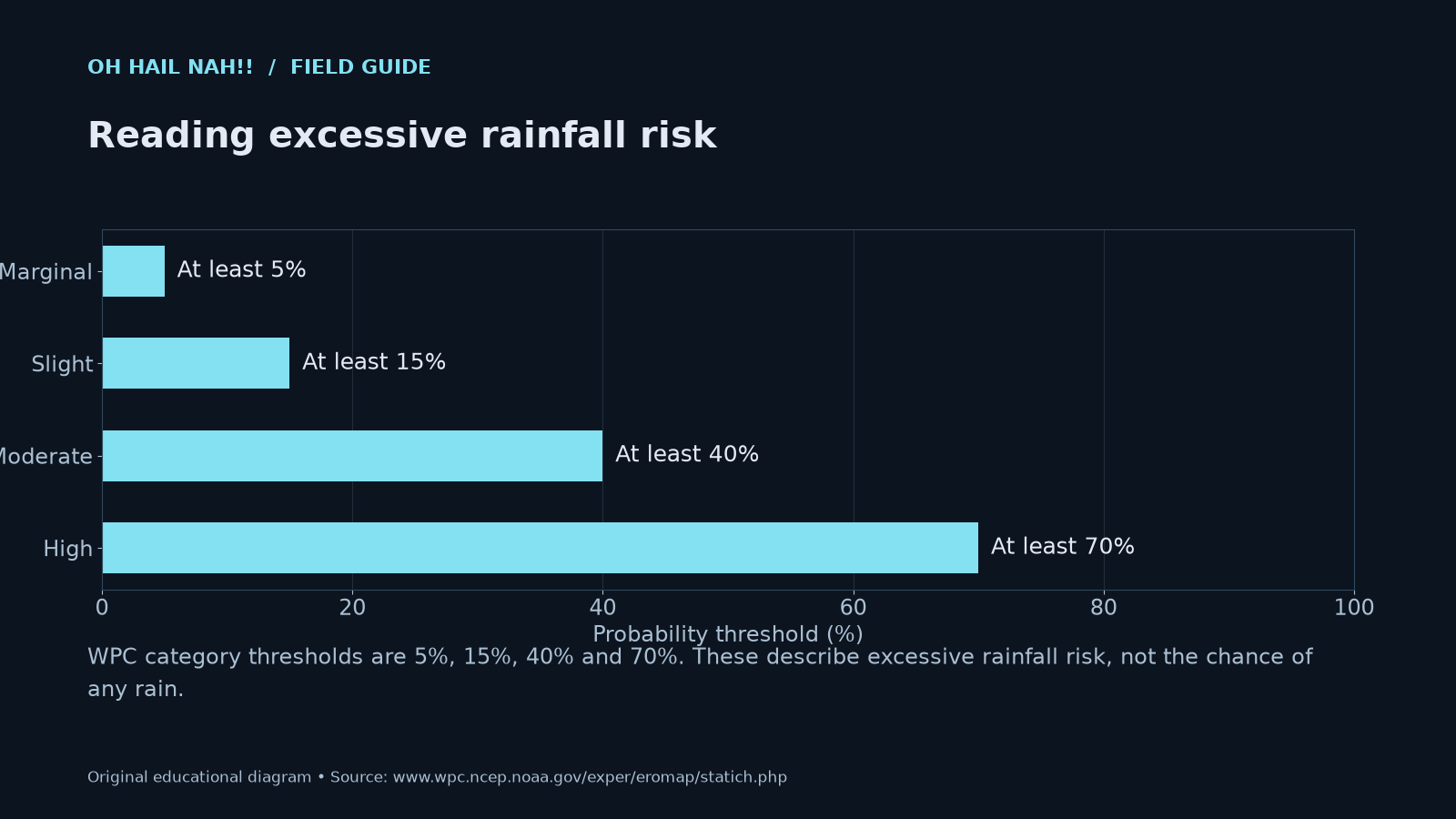
WPC category thresholds are 5%, 15%, 40% and 70%. These describe excessive rainfall risk, not the chance of any rain.
The short answer
A Moderate Risk (level 3 of 4) on the Weather Prediction Center's Excessive Rainfall Outlook means there's at least a 40% chance rain will exceed flash flood guidance within 25 miles of your location. WPC describes it as "numerous flash floods likely." It is not a warning. It's your cue to plan routes and watch for alerts.
The outlook comes first, often days ahead. Flood watches, warnings and emergencies come later, from your local National Weather Service office.
What the Excessive Rainfall Outlook is
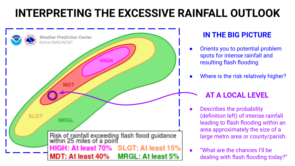
The Excessive Rainfall Outlook, or ERO, is a national map from the Weather Prediction Center (WPC), part of NOAA's National Weather Service. It forecasts one thing: the probability that rainfall will exceed flash flood guidance within 40 kilometers (25 miles) of a point.
WPC issues it for today (Day 1) through Day 5. Days 1 to 3 use all four risk levels. The Day 4 and Day 5 outlooks only use Slight and Moderate.
What "flash flood guidance" means
Flash flood guidance is an estimate of how much rain, over 1, 3 or 6 hours, it would take to bring rivers and streams up to bankfull. The 12 NWS River Forecast Centers that cover the lower 48 produce it, and WPC stitches it into one national map (WPC product description).
In plain terms, it's how much rain your area can take in a few hours before creeks top their banks. That number isn't fixed. Soaked ground, burn scars and pavement all mean less rain is needed to cause trouble.
Marginal to High: the four levels
| Level | Chance rain exceeds flash flood guidance within 25 miles | How WPC describes it |
|---|---|---|
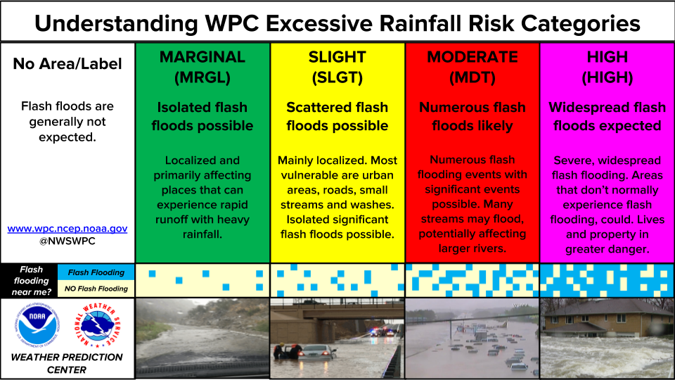
| Marginal (MRGL) | At least 5% | Isolated flash floods possible. Localized, mostly places that see rapid runoff in heavy rain. |
| Slight (SLGT) | At least 15% | Scattered flash floods possible. Urban areas, roads, small streams and washes are most vulnerable. |
| Moderate (MDT) | At least 40% | Numerous flash floods likely. Significant events possible; many streams may flood, possibly affecting larger rivers. |
| High (HIGH) | At least 70% | Widespread flash floods expected. Areas that don't normally flood could. Lives and property in greater danger. |
Sources: WPC product description and WPC's "Understanding Excessive Rainfall Risk Categories" graphic.
When no area is drawn, the map reads: "The probability of rainfall exceeding flash flood guidance is less than 5 percent."
What the percentage really means
The number is not a chance of rain. It's the chance that rain heavy enough to cause flash flooding falls within 25 miles of a given spot. WPC says that area works out to roughly the size of a large metro area or a county or parish, and frames it as: what are the chances I'll be dealing with flash flooding today?
The numbers can look low. WPC explains that flash floods are rare at any one exact location, so the probability stays low even when forecasters are confident flooding will happen somewhere in the region. When WPC draws a risk area at all, it expects at least some flash flooding. A 40% Moderate is a big deal.
Why High Risk days matter
High Risk days are a big deal. According to WPC's High Risk climatology, High Risk days correspond to about two out of every five flood-related deaths and a significant majority of flood-related property losses in the lower 48.
Outlook vs. watch vs. warning vs. emergency
| Step | Who issues it | When | What it means | Phone alert? |
|---|---|---|---|---|
| Excessive Rainfall Outlook | WPC (national) | Up to 5 days ahead | Chance of flash-flood-level rain within 25 miles | No |
| Flood Watch | Your local NWS office | Before the event | Conditions are favorable for flooding. Be prepared. | No |
| Flash Flood Warning | Your local NWS office | Imminent or happening | Flash flooding is imminent or occurring. Move to higher ground. | Only with a "considerable" tag |
| Flash Flood Emergency | Your local NWS office | Happening | Severe threat to life; catastrophic damage imminent or occurring | Yes |
Sources: NWS Flood Watch vs. Warning, NWS Impact-Based Flash Flood Warnings fact sheet.
An outlook usually comes first, but not always. Flash floods can develop with short lead time, and WPC notes that risk areas sometimes appear suddenly. If a warning is issued for you, act on the warning, whatever the outlook said. Our guide to Flash Flood Emergency vs. Flash Flood Warning covers the top two rungs.
When it's issued and how to read the map
WPC updates the Day 1 outlook on a regular schedule three times a day, and Days 2 through 5 twice a day. Forecasters can also issue unscheduled updates when things change (schedule). The main forecast day runs from 12Z to 12Z, which is 7 a.m. to 7 a.m. Central Daylight Time (6 a.m. to 6 a.m. once we're back on standard time).
WPC says a Slight, Moderate or High Risk can ideally be advertised two to three days ahead, then upgraded as confidence grows, so check the map more than once on a rainy week. Risk areas are nested, with Moderate sitting inside larger Slight and Marginal zones. Read the discussion under the map too. It's where forecasters explain why, such as soaked soils, burn scars or storms training over the same area. If this feels like the SPC severe weather outlook, that's the idea.
What to do at each level
- Marginal: Normal day for most people. Know if you live or drive near spots that flood fast: low-water crossings, washes, underpasses.
- Slight: Check your local NWS forecast and whether a Flood Watch is out. Plan routes that skip low spots. Charge your phone.
- Moderate: Plan your day around it. Check the Day 1 map and your local NWS office. Reroute or reschedule travel through flood-prone areas. Know your route to higher ground. Campers and hikers: stay out of canyons, washes and burn scars. Make sure a warning can actually reach you. Standard Flash Flood Warnings don't buzz your phone, so see alerts that wake you up.
- High: Serious. Cancel travel you don't need. Stay somewhere you can reach higher ground without crossing water. Follow local officials.
- Any level, any time: Turn Around Don't Drown. The NWS says 6 inches of fast-moving water can knock over an adult, 12 inches can carry away most cars and 2 feet can carry away SUVs and trucks. Over half of flood-related drownings happen when a vehicle is driven into floodwater, according to CDC data cited by the NWS.
A change WPC has proposed
In August 2026, the NWS asked for public comment on moving the outlook from four levels to five. The proposal adds an "Enhanced" level (25%) between Slight and Moderate and puts Level 1 through 5 labels on each category, matching the SPC scale. Under the proposal, Moderate would become Level 4. Comments closed September 5, 2026. As of this writing it is still a proposal, and the current four-level scale is in use. We'll update this page if it changes.
Questions people ask
What does a Moderate Risk of excessive rainfall mean? It means WPC forecasts at least a 40% chance that rain will exceed flash flood guidance within 25 miles of a point, and describes it as "numerous flash floods likely." It's an outlook, not a warning.
Is 40% the chance it will rain? No. It's the chance that rain heavy enough to reach flash flood guidance falls within 25 miles of your location. Flash floods are rare at any single spot, so 40% is a high number for this product.
Is an Excessive Rainfall Outlook the same as a Flood Watch? No. WPC issues the outlook nationally, up to five days ahead. A Flood Watch comes from your local NWS office when conditions are favorable for flooding. Warnings and emergencies follow if flooding becomes imminent or is happening.
How far ahead does WPC issue the outlook? Up to five days. Day 1 is updated three times a day on a regular schedule, and Days 2 through 5 twice a day. Days 4 and 5 only use the Slight and Moderate levels.
How serious is a High Risk of excessive rainfall? Very. WPC says High Risk days correspond to about two out of every five flood-related deaths and a significant majority of flood-related property losses in the lower 48.
Will my phone alert me for an Excessive Rainfall Outlook? No. Outlooks and Flood Watches don't trigger Wireless Emergency Alerts. Only Flash Flood Warnings with a "considerable" or "catastrophic" damage threat do.
Get ready, then keep watching
On a Moderate or High Risk day near you, we're watching too. Our live stream breaks in when flooding threatens, and you can set up local alerts and radar in a couple of minutes. Our storm kit checklist covers what to keep ready before the rain.
This guide supports personal planning. It does not replace official warnings or local evacuation orders. When a warning is in effect for you, act on it first. Official forecasts: weather.gov and wpc.ncep.noaa.gov.
Keep reading
- Flash Flood Emergency vs. Flash Flood Warning: what changes when the NWS escalates, and when to leave.
- Set up alerts that wake you up: standard flash flood warnings don't reach your phone. Here's how to hear them.
- How to read the new SPC outlook maps: the severe weather version of this map.
- El Niño winter 2026–27: why the southern storm track may run wetter this winter.
Sources
- NOAA/NWS Weather Prediction Center, Excessive Rainfall Outlook
- WPC, Product description: Excessive Rainfall Outlooks
- WPC, Understanding Excessive Rainfall Risk Categories
- WPC, Interpreting the Excessive Rainfall Outlook
- WPC, ERO High Risk climatology
- NWS, Public Information Statement 26-57: Proposed changes to the ERO
- NWS, Flood Watch vs. Warning
- NWS, Impact-Based Flash Flood Warnings fact sheet
- NWS, Turn Around Don't Drown